Fishing
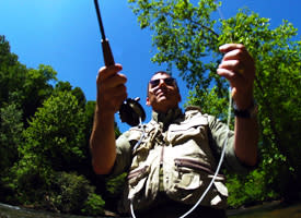
Dahlonega is located in the foothills of the Blue Ridge Mountains and one-third of the county is in the Chattahoochee National Forest, making Dahlonega a great place for trout fishing. All of the streams described below are easily accessible from Dahlonega, and contain stocked rainbow, native rainbow, and brown trout except where noted. However, the trophy trout population in  the streams has been sharply reduced in recent years by the encroachment by otter.
A valid Georgia Fishing License with a trout stamp is required. Holders of an honorary fishing license do not require trout stamps. It is illegal for an angler to have bait or tackle in his or her possession when that bait and gear is not legal on the stream being fished.
Georgia fishing licenses are available online and at the following Dahlonega locations:
Walmart Super Center
(706) 867-6912
270 Walmart Way, Dahlonega, GA 30533
www.walmart.com
Private & Guided Fly Fishing
Frog Hollow Fly Fishing
(706) 244-4372
900 Frog Hollow Road, Dahlonega, GA 30533
www.froghollowflyfishing.com
Montaluce Fly Fishing Experience
(706)-867-4060
501 Hightower Church Rd Dahlonega, GA 30533
https://www.montaluce.com/plan-your-visit
Public Fishing
Rivers, lakes, and reservoirs in the Dahlonega area that are good for fishing are presented below.
Etowah River
Fishing above Jay Bridge and the Etowah tributaries upstream from the Castleberry bridge to Jay Bridge is limited to the fishing season. The best fishing is probably in the Wildlife Management Area (WMA). To reach this area from Dahlonega follow Hwy 19N 2.1 miles and turn left on Wahsega Road. Continue 8 miles to the entrance of the Camp Frank D. Merrill Ranger Camp, turn left on FS 28-1 and go 1.6 miles to the Etowah River. Primitive camping areas are upstream on the right. Tributaries include Jones Creek, Montgomery Creek and Nimblewill Creek.
West Fork of the Montgomery Creek
Montgomery Creek is in the Blue Ridge WMA. To reach this creek from Dahlonega follow Hwy 19N 2.1 miles and turn left on Wahsega Road. Continue 8 miles to the entrance of the Camp Frank D. Merrill Ranger Camp. Turn left on FS 28-1 and after 0.2 miles turn right onto FS 141 at the Ranger Gym (this road may not be marked and can only be traveled in a vehicle with high suspension). Shortly after passing the Gym you will ford the Etowah River. Follow this road, keeping to the left, for about 2 miles to the West Fork of the Montgomery Creek. Parking is on left across creek. Open only during fishing season.
Jones Creek
Jones Creek is not stocked and contains native brown trout almost exclusively. Anglers are restricted to using artificial lure on Jones Creek and its tributaries in the Blue Ridge WMA. To reach this creek from Dahlonega follow Hwy 19N 2.1 miles and turn left on Wahsega Road. Continue 8 miles to the entrance of the Camp Frank D. Merrill Ranger Camp. Turn left on FS 28-1 and go 4.3 miles to FS 77. Turn right on FS 77 and continue past the game checking station 1.3 miles to FS 77-A on the left. Follow 77-A 1.6 miles to the FS sign at Jones Creek. The road to the right goes along Jones Creek for 1 mile before reaching a dead end. Primitive camping is permitted in this area. The left fork continues about 400 yards to Lance Creek. Jones Creek can also be reached by Hwy 52W for 8 miles to Nimblewill Road on the right. Go 2 miles on Nimblewill Road to FS 28-1 on the right. Follow FS 28-1 2.1 miles to FS 77 on the left and then continue as above to FS 77-A. Open only during fishing season.
Nimblewill Creek
From Dahlonega follow Hwy 52W for 8 miles to Nimblewill Road on the right. Take Nimblewill Road 2.3 miles to Nimblewill Church on the right. Continue straight on unpaved FS 28-2 crossing over Nimblewill Creek after 1 mile. Continue on FS 28-2 for 3 more miles. Nimblewill Creek will appear along the right side of the road. Camping is available along the creek. Open only during fishing season.
Waters Creek
Waters Creek, located just 10.5 miles from Dahlonega, is a trophy trout stream and only fishing with artificial lures with a single barbless hook size 6 or smaller is allowed. Fishermen will find a variety of fish including brown trout, rainbow trout and brook trout here. Whether you’re baitcasting, fly fishing or spinning your chances of getting a bite here are good. So grab your favorite fly fishing rod and reel, and head out to Waters Creek. Waters Creek is in the Chestatee WMA and is open during the trout season on Wednesdays, Saturdays, and Sundays. In addition to a fishing license and a trout stamp, a Wildlife Management Area (WMA) stamp is required when fishing on Waters Creek. Size limits are 22 inches for brown and rainbow and 18 inches for brook trout. Smaller trout must be returned to the water immediately. Only one trout these sizes or larger may be kept each day and a maximum of 3 for the season. Waters creek flows into Dicks Creek. For directions see Dicks Creek below. It is required that anglers check in and out at the Camp Frank D. Merrill Ranger Station at the entrance to Waters Creek.
Dicks Creek
Dicks Creek is in the Chestatee WMA and is open only during the fishing season. This creek has a number of pretty falls and is easily accessible. To reach it follow Hwy 19N from Dahlonega for 12 miles to the Forest Service sign and sign for Mt. Pisgah Church on the left. Turn left and follow this paved road. The road crosses over Dicks Creek in about 0.6 miles. Continue on this road with Dicks Creek on the left. The creek is mostly on private property almost to the confluence of Dicks Creek and Waters Creek at the bridge 2.7 miles from Hwy 19. Dicks Creek falls is just downstream from this junction. For access to Waters Creek turn left at the bridge on FS 144 and check in at the ranger station past a private residence. FS 144 is closed except during fishing season. The road along Dicks Creek continues for 2 more miles as unpaved FS 34 which is not maintained for automobiles.
Noontootla Creek
Noontootla Creek is in the Blue Ridge WMA and is formed by the confluence of Stover Creek, Chester Creek and Long Creek known as The Three Forks Area. Noontootla Creek and its tributaries are not stocked and are managed to imitate a natural stream with an unharvested trout population. Noontootla Creek and its tributaries are open throughout the year. Only fish 16 inches in length or greater may be kept and only artificial lures are allowed. To reach the Three Forks Area leave Dahlonega on Hwy 19N 2 miles to Camp Wahsega Road on the left. Take Camp Wahsega Road 8 miles to the entrance of the Camp Drank D. Merrill Ranger Training Camp. Turn left on FS 28-1 and go 4.3 miles to FS 77. Turn right on FS 77 and continue to the top of ridge at Winding Stair Gap at the junction of 4 roads (FS 77, FS 42, and FS 58). FS 42 will go left and right. Take FS 58 2.7 miles down the other side of the ridge to the Three Forks Area at the bottom of the mountain.
Cooper Creek
Cooper Creek is open only during the fishing season. To reach Cooper Creek from Dahlonega travel on Hwy 60N for about 24 miles until reaching the road to Corinth Church on the right. Turn right and follow this road about a mile to Forest Service sign on left. Turn left and proceed on FS 236 for about 3 miles to Cooper Creek. Cooper Creek flows through Cooper Creek Scenic Area.
Rock Creek
Open year-round Rock Creek can be reached from Dahlonega by following Hwy 60 12 miles past Suches. After passing Cooper Creek Groceries and Deep Hole Recreation area on the left, turn left at the fish hatchery sign. Cross over the Toccoa River and continue for about 1 mile. Rock Creek will appear on the right. The road follows Rock Creek for 2 miles to the hatchery and another 2 miles to Rock Creek Lake, a small man-made lake which is also stocked with trout.
Dockery Lake
This lake which is managed by the U.S. Forest Service is a great lake for kids. Camping, hiking and fishing platforms are available. Fishing Rodeos are held occasionally in the summer. Follow Hwy 60N from Dahlonega for about 9 miles. Forest Sign on the Right.
Lake Winfield Scott
This pretty mountain lake is stocked with rainbow trout and is managed by the U.S. Forest Service. Hiking, camping and fishing platform are available. Boats with motors are not allowed. To reach Lake Winfield Scott, follow Hwy 60N from Dahlonega through Suches. Turn right on Hwy 180 and turn right at Forest Service Sign. Distance from Dahlonega is approximately 22 miles.
Lake Lanier
Lake Sidney Lanier, completed in 1956 covers 38,000 acres and touches 5 counties - Lumpkin, Hall, Dawson, Forsyth and Gwinett. In addition, there are 19,000 acres of controlled shore land above 1070 mean sea level. The types of fish found in the lake are spotted bass, striped bass, largemouth bass, black crappie and walleye.
Lake Zwerner
Lake Zwerner is located north of downtown along Morrison Moore Parkway East. This lake (also known as the Yahoola Creek Reservoir) provides most of the City of Dahlonega's water supply along with a great recreational area. The lake offers fishing, mountain and lake side walking trails, and picnic areas. The types of fish found in the lake are bream and bass.
Waterfalls
Download North GA Waterfall AppFrom roaring waterfalls to gurgling cascades, the mountains of North Georgia offer some of the best falls in the United States. While there are over 120 waterfalls in North Georgia, these are some of the most...
Read MoreKayaking, Canoeing & Tubing
The Etowah and the Chestatee Rivers near Dahlonega provide enjoyable and challenging canoeing and kayaking with predominately Class I and II rapids. Before planning trips on these rivers, you should consult persons knowledgeable about the...
Read More


