Waterfalls
From roaring waterfalls to gurgling cascades, the mountains of North Georgia offer some of the best falls in the United States. While there are over 120 waterfalls in North Georgia, these are some of the most popular falls in the Dahlonega area.
For more information about North Georgia's waterfalls, visit Jack Anthony's "Waterfalls of North Georgia".
For a full list of waterfalls and directions, download our Waterfall Guide & Map!
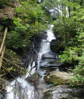
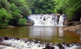 Dicks Creek Falls is located in the Chattahoochee National Forest just below the confluence of the Dicks and Waters Creek.
To reach the falls go north from Dahlonega 13.7 miles on US19 to Mt. Pisgah Church Road (one-half mile before reaching the junction of US19 and US129 at Turner's Corner) marked by a US Forest Service sign indicating Waters Creek Campground. Turn left on this road and go 2.6 miles to the falls which will be on the left. This falls and the shoals above it are popular for wading and sunning in the summer, however, care should be exercised when walking on the slippery rocks and under no circumstances should one dive into the pools.
For more information, visit Jack Anthony's "Waterfalls of North Georgia".
Amicalola Falls
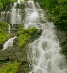 Amicalola Falls is located in Amicalola State Park on Hwy GA52 near Dawsonville, Elijay, and Dahlonega. This beautiful waterfall cascades 729 feet to a reflecting pool at the bottom. A walkway that goes from the bottom to the top of the falls was completed late in 2001. A paved walkway begins near the reflecting pool at the bottom of the falls. The walkway passes along a series of cascades and about one-third of the way up becomes a combination of viewing platforms and steps to the top affording spectacular views of this outstanding attraction. Parking is available at the bottom, at the top, and near the middle of the falls so it is possible to start the walk from either the middle, top or bottom.
To reach the falls from Dahlonega head west on GA52 for 4 miles, then turn right to stay on GA52 for 14 miles. Turn right onto Amicalola Falls State Park Road, then take the first left to stay on Amicalola Falls State Park Road.
For more information, visit Jack Anthony's "Waterfalls of North Georgia".
DeSoto Falls
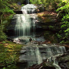 The DeSoto Falls are located in Lumpkin County in the Chattahoochee National Forest DeSoto Falls Scenic Area. Trails lead to 2 different falls on Frogtown Creek. The lower falls is .3 miles downstream from the trailhead, the second is .75 miles upstream. According to legend Spanish armor belonging to the Spanish explorer Hernando De Soto or one of his men was found near here which led many to believe that the expedition passed through this region in 1540 in their attempt to find gold.
To reach the falls from Dahlonega head north on GA9 / Morrison Moore Parkway for 13 miles, then turn left onto US-129 for 4 miles. The trails will be on the left.
For more information, visit Jack Anthony's "Waterfalls of North Georgia".
Raven Cliff Falls
 The trail to Raven Cliff Falls is 5 miles round trip along Dodd Creek to the cliffs where the creek plunges through a narrow opening in the cliff. Along the trail to Raven Cliff Falls which follows along Dodd Creek, there are several falls. This a pretty trail and is moderate walking through rhododendron and hemlock forests following the creek by numerous small waterfalls. However, the trail becomes fairly steep near the end. The trail and falls are located within the Mark Trail Wilderness Area.
To reach the falls from Dahlonega head north on GA9 / Morrison Moore Parkway for 13 miles, then turn right onto US-129 for 7 miles. Turn left onto GA75-Alt for 6 miles, then turn left onto GA348 / Richard B Russell Scenic Highway. After 2.5 miles, the falls will be on the left.
For more information, visit Jack Anthony's "Waterfalls of North Georgia".
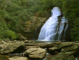
Dukes Creek Falls
 Dukes Creek Falls is actually on Davis Creek as it joins Dodd Creek to form Dukes Creek. For those not who do not want to take the 1-mile walk to the bottom of the gorge, there is an observation deck 0.1 miles from the parking area which has a distance view of the falls. The falls drops approximately 200 feet. The 1 mile relatively easy walk to the falls from the parking area is by way of switchbacks into the Dukes Creek Gorge. Steps are provided on the steep sections of the trail down. Upon reaching the bottom a 300-foot long walkway connects 3 observation decks which along with the walkway afford excellent views of the falls and shoals on all three creeks.
To reach the falls from Dahlonega head north on GA9 / Morrison Moore Parkway for 13 miles, then turn right onto US-129 for 7 miles. Turn left onto GA75-Alt for 6 miles, then turn left onto GA348 / Richard B Russell Scenic Highway. After 1.5 miles, the falls will be on the left.
For more information, visit Jack Anthony's "Waterfalls of North Georgia".
Helton Creek Falls
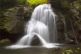
 There are two falls on Helton Creek in the Chattahoochee National Forests. The upper falls which has an observation deck is about 50 yards above the lower falls.
To reach these falls go north from Dahlonega on US19 21.5 miles to Neels gap. Go another 1.7 miles to Helton Creek Rd. on the right. Follow Helton Creek Rd. 2.3 miles to a Forest Service parking area on the right. About half of this distance is paved. The well-maintained trail with steps to both falls is about 200 yards and not very strenuous. The walk to both falls is about 200 yards on a well-maintained trail with steps on the steeper slopes.
For more information, visit Jack Anthony's "Waterfalls of North Georgia".
Anna Ruby Falls
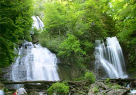 Two falls, one on Curtis Creek and the other on York Creek together are called Anna Ruby Falls. Curtis Creek and York Creek join at the foot of the falls to become Smith Creek. The Curtis Creek falls plunges 153 and York Creek falls 50 feet. A paved walkway leaves the Visitors Center and follows Smith Creek on a beautiful interpretive walk to the observation platforms at the base of the two falls.
To reach the falls from Dahlonega head north on GA9 / Morrison Moore Parkway for 13 miles, then turn right onto US-129 for 7 miles. Turn left onto GA75-Alt for 8 miles, then turn right onto GA17 / GA75 for 0.3 miles. Take the 2nd left onto GA-356 for 1.3 miles, then a slight left onto Anna Ruby Falls Road. Follow the signs 3.5 miles to Anna Ruby Falls parking area.
For more information, visit Jack Anthony's "Waterfalls of North Georgia".